USING SATELLITES TO COUNT WHALES IN THE ARCTIC
Featured

Featured
December 01, 2020 | ![]() ARCTIC WATCH
ARCTIC WATCH
Starting in 2021, the team at Weber Arctic is supporting a satellite imagery project. This ambitious endeavor has the potential to reshape conservation efforts globally.
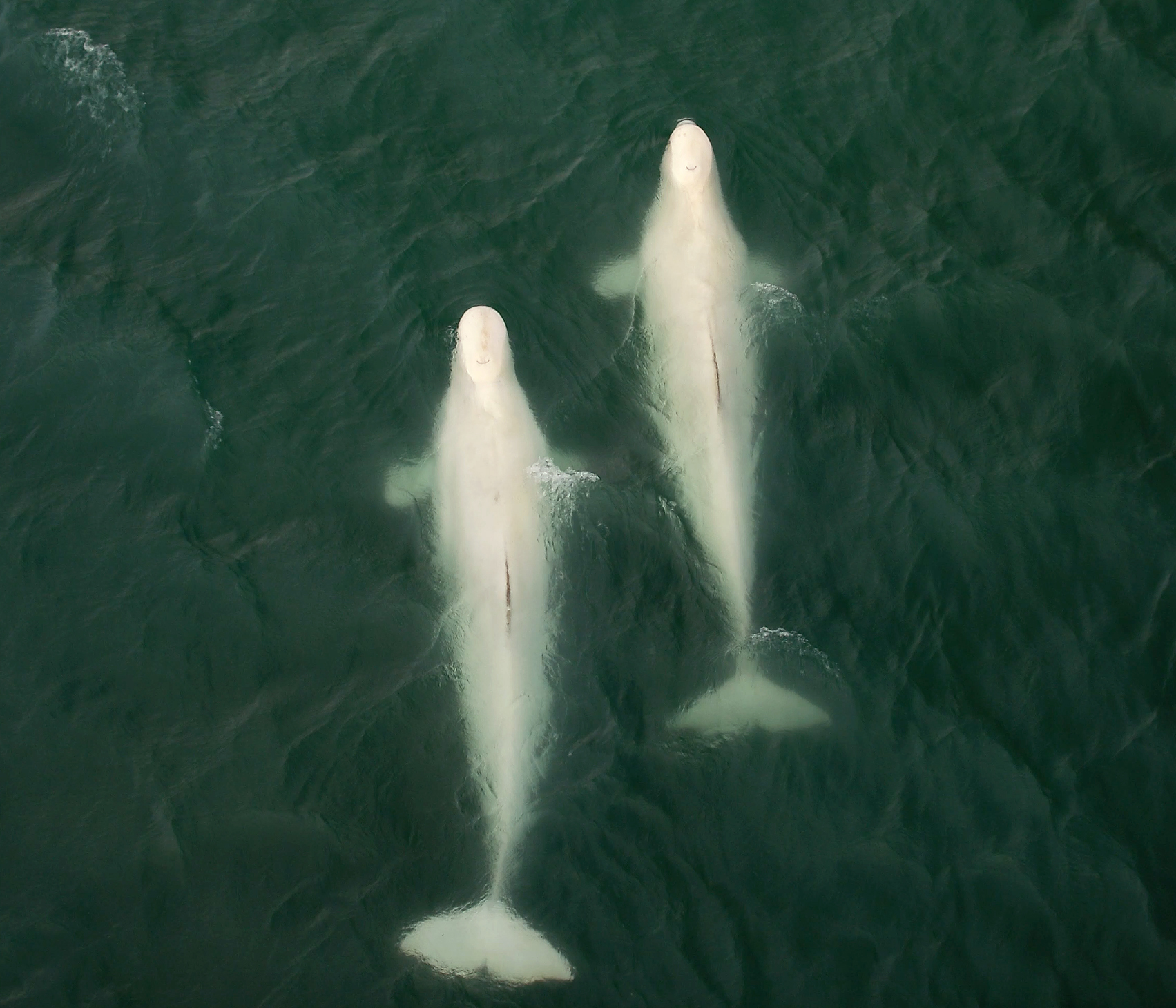
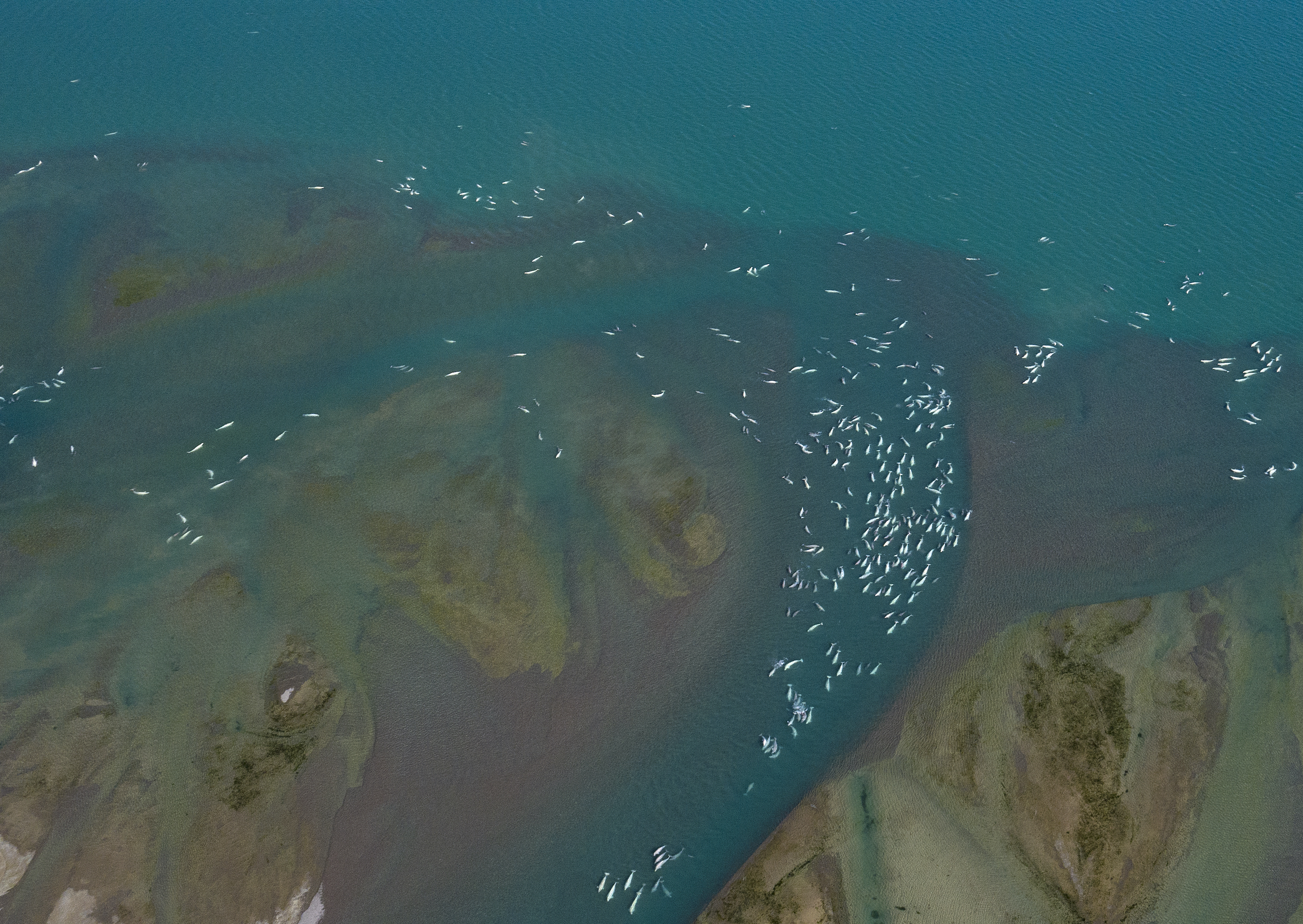
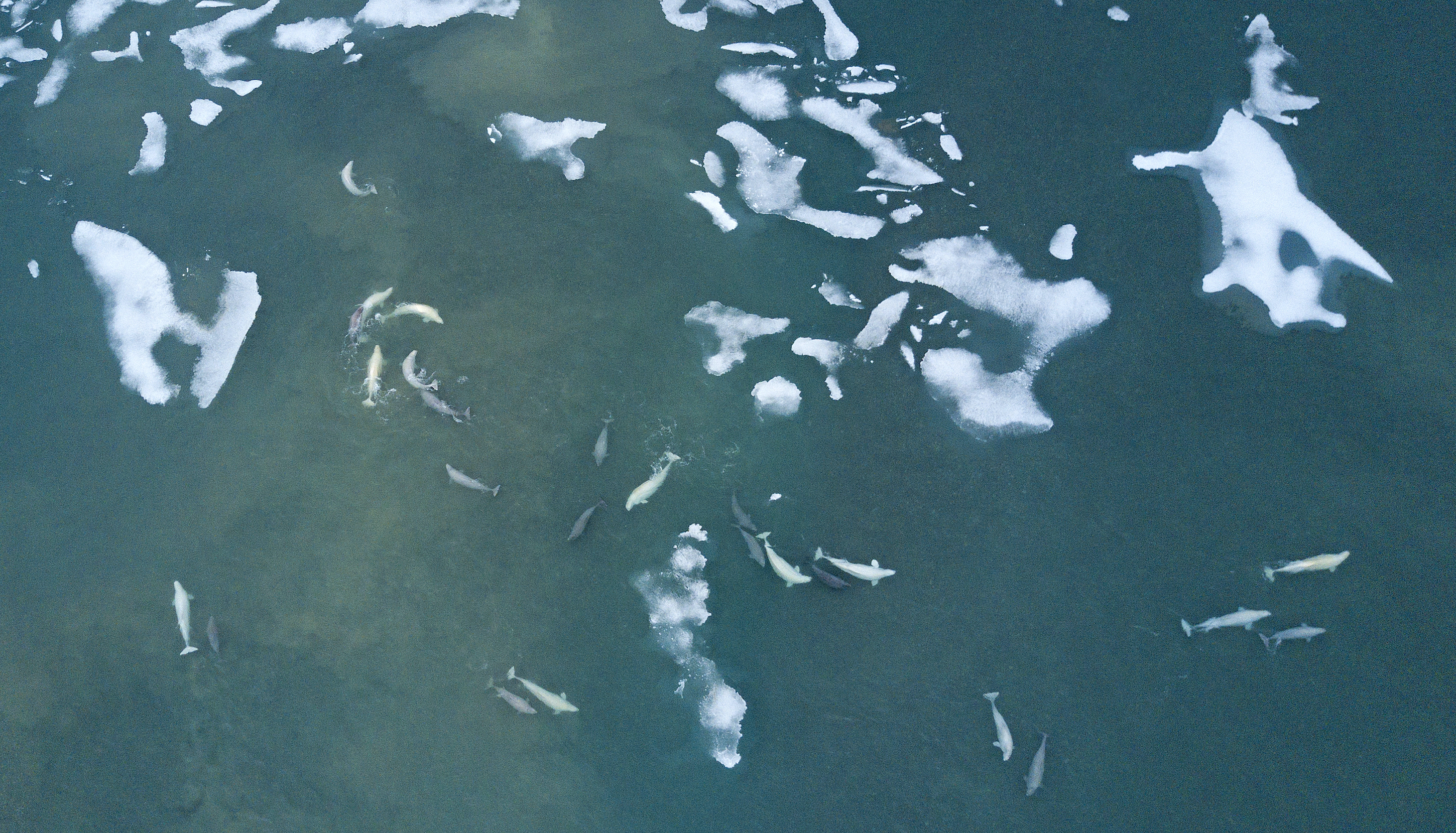
It’s difficult to imagine more convenient and consistent whale watching than at Arctic Watch. In leisurely moments—after dinner, maybe, while the northern sun lingers—guests can stroll on their own down to Cunningham Inlet’s gravel shore to watch the belugas swim and play, sometimes only a few meters away. Every year during July and August, approximately 2000-3000 beluga whales visit as they move west from their overwintering grounds in Baffin Bay, following the melting ice. The outflow of freshwater from the Cunningham River makes the inlet pleasantly warm (by beluga standards), and the animals take advantage of the spa-like conditions to nurse their calves, socialize, and slough off dead skin and saltwater parasites on the river stones. Besides giving Weber Arctic guests some fantastic sightings and memories, such a reliable aggregation of a relatively elusive species is highly valuable to science. The latest chapter in beluga research on Somerset has big ramifications, to benefit whales worldwide: drone photos of the whales will be put to use in developing algorithms to search for whales in satellite images. This will allow researchers to gather more information more rapidly about populations and migratory behavior. This will help conservation decisions in a rapidly changing ocean.
Dr. Ludwig Houégnigan of the Polytechnic University of Catalonia in Barcelona is at the forefront of this work. He began his career as an engineer and a researcher in acoustics and signal processing but gradually sought to apply those areas of expertise with more biological, environmental purposes. “What I’ve been doing over the years,” he says, “is designing algorithms to detect, classify and localize marine mammals through their vocalizations”. Initially, he started with underwater recordings, capturing marine mammal sounds with the aim of automating the localization of marine mammals through sound and identifying the species that made them in order to facilitate the daunting task of figuring out which whales are where and in what numbers. This approach was not without major frustrations, however. In the field, researchers might watch marine mammals pass by within sight and record absolutely no sounds, possibly because of distance or the limitations of the sensors or their positions or simply because the animals were not using sound.
Dr. Houégnigan began to wonder what else might be possible. “One night I woke up at two or three in the morning,” he recalls, “and I thought, what about satellites? Would the resolution be good enough to visualize the marine mammals? ” Satellite images would allow researchers to look globally, to venture into the most remote or inaccessible regions, and to cover expanses of terrain that would otherwise be prohibitively expensive and inefficient—probably impossible—to survey. But the same gigantic scale that was an asset of satellite data was a challenge, too. A potentially overwhelming one.
Marine mammals and other large wild animals, both on land and in the ocean, are captured in the very high resolution images taken from space, but the task of picking them out would be, for human eyes and brains, an insurmountable needle-and-haystack situation. Instead, a purpose-made search engine would need to be built. Dr. Houégnigan’s first task was figuring out if and how such a thing could be done. Once he’d determined that advances in deep learning, supercomputing, and image resolution would make the idea not only possible but feasible, he wrote a proposal for a small project that was funded by the European Space Agency.
“Basically the idea is now to apply this to species that are endangered in order to gather as much data about their numbers and their migration as we can,” Dr. Houégnigan says. Whales, though large, are difficult to study for the obvious reason that they spend most of their lives underwater. Almost nothing is known about some species and populations. Dr. Houégnigan points to the example of Omura’s whales, a more than 10-meter long species that was only identified in 2006 (from caracasses) and first observed alive off of Madagascar in 2015 by Salvatore Cerchio and his team. “So we have a new species,” Dr. Houégnigan says, “and we don’t even know what the status of the species is. Is it endangered? Critically endangered?” He points out that if a species is in a precarious situation, we would need to react quickly in order to protect it, and if traditional, field-based methods of assessing a population have failed even to detect that population, they are unlikely to be nimble enough to gather the necessary data in time to form a conservation plan. Biologists end up flying blind.
But why is it important to count whales? Why do we need to know where they go? “It depends how you see it,” Dr. Houégnigan says. “From a pure knowledge point of view, you just want to know how many of them there are, you want to know about their habitat and migration habits. I think that’s how I started, when I started working with marine mammals, but more deeply then, the emergency of the biodiversity crisis is certainly the fundamental driver for this research. We have become increasingly knowledgeable about the biodiversity crisis, and therefore it is more urgent to document what is happening. Another driver is that the balance of the oceans has been put in peril by climate change. By knowing more about what is happening to marine mammals, about their status, their habitat, and by basically making a census, it is a way to know how the balance of the oceans is doing.”
In a perfect world, species would be seen as valuable in their own right, but, as climate change accelerates, necessitating a kind of conservation triage, it can be useful to contextualize some species in terms of their capacity to sequester carbon. Not only do large whales sequester an average of 33 tons of CO₂ in their lifetimes, their waste products have a multiplier effect on the growth of phytoplankton, which, globally, captures something like 40% of all CO₂ produced and contributes more than half of atmospheric oxygen. If whale populations grew enough to increase phytoplankton productivity by just 1%, this would be the carbon-capture equivalent of adding two billion mature trees. “Right now there is the beginning of a discussion about harnessing the conservation of whales as a natural-based solution to climate change,” Dr. Houégnigan says, but he also emphasizes that entire ecosystems must be functional in order to be effective carbon sinks and that other, often less charismatic species, also play critical roles in this balance. Furthermore, protecting individual species often means protecting large areas of their habitat for feeding and breeding.
One reason Somerset Island and its belugas are of special interest to Dr. Houégnigan’s research is that, in terms of climate, the Arctic is the region experiencing the highest rate of change globally. This means that its species have the dubious distinction of offering early indications of the effects of that change. Then there is a more technical reason. Teaching computers to search a massive archive of satellite data for the specific tiny blips that are whales will not be easy, especially given that even individuals belonging to a single species of whale might look very different in different moments due to positioning, behavior, sea state, rate of travel, and so on. A strategy for mitigating this is to accumulate a large database of drone images where animals can be accurately counted. The images will be mathematically altered to resemble satellite images and used as examples to help the AI calibrate what it’s looking for.
“We can work directly with the satellite images to locate the animals,” Dr. Houégnigan says, “but what is happening with a lot of species is that they are very small or they are very evasive. On Somerset, we don’t have this problem. Belugas in Somerset are small but you cannot miss them. So then you can train an algorithm to detect them in other areas. It’s transfer learning. You start with something you can get a lot of data from, and then you transfer it to something you have less knowledge and data about.”
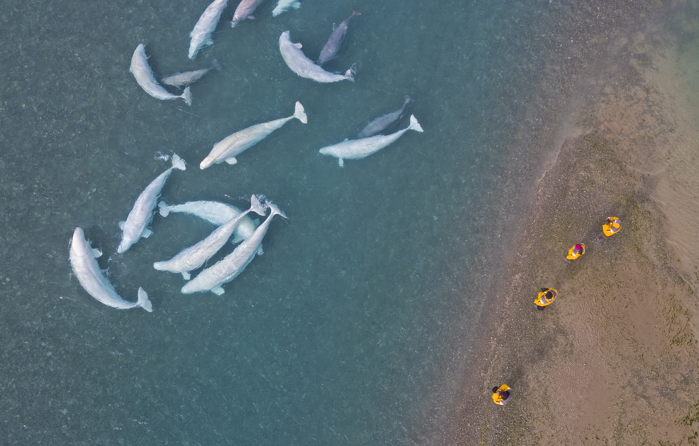
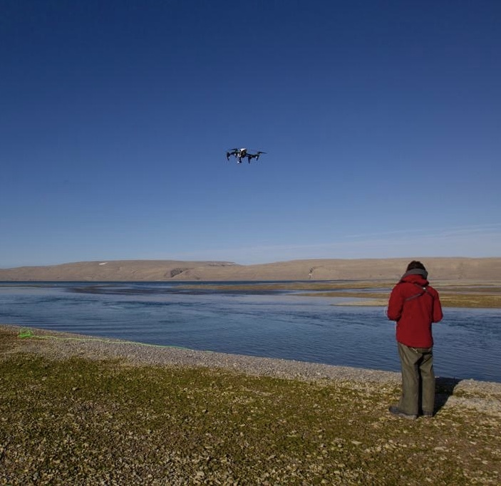
Eventually, this process could be applied to other species, even terrestrial ones like polar bears, which are much more difficult to spot in satellite images. Nansen Weber, with years of practice photographing belugas in the Cunningham Inlet by drone, is an ideal collaborator. “He makes the most incredible images,” Dr. Houégnigan says. “Better than I could do right now. It takes experience to get to that level.”
Dr. Houégnigan has found, too, that he enjoys working in his lab and his office, managing and analyzing data. “When you look at satellite images,” he says, “so many are so beautiful and so stunning. I am traveling without moving.”
It’s a good thing Dr. Houégnigan enjoys his work, because his task is a mammoth one, with the potential not only to shape the global conservation of marine mammals at a critical juncture but to assist and influence countless other projects. “There’s a lot of work to do,” he says with quiet relish. “There’s years of development ahead.
As a guest, see beluga whales at Arctic Watch during our Arctic Watch Discovery Experience and Ultimate Canadian Arctic Experience.
We understand that booking a trip like this is a big endeavour. Please reach out to us with any questions that you might have regarding your upcoming adventure.